I recently came across this quote from Kirkpatrick Sale’s 1980 book Human Scale and it succinctly relates a fundamental truth about the purpose of cities.
Cities are meant to stop traffic. That is their point. That is why they are there. That is why traders put outposts there, merchants put shops there, hoteliers erected inns there. That is why factories locate there, why warehouses, assembly plants and distribution centers are established there. That is why people settle and cultural institutions grow there. No one wants to operate in a place that people are just passing through; everyone wants to settle where people will stop, and rest, and look around, and talk, and buy, and share.
Cities, in short, should be an end, not a means. Rationally one wants to have traffic stop there, not go through, one wants movement within it to be slow, not fast.
Sale goes on to list four ways in which cities should think about slowing traffic down:
Cities should not try to move people to facilities but provide facilities where the people are.
Cities should be small enough so that inter-community trips, when necessary, could be managed either on foot, by bike, or with some simple subway or trolley system.
Cities should attempt to slow down the flow of traffic, particularly with plenty of squares and plazas and parks, places where wheeled vehicles are forced to halt, endpoints that invite stopping and resting.
Cities should try to bring home and workplace back together.
Update: Some alert readers let me know that Kirkpatrick Sale is a left-wing secessionist, which has brought him and his various organizations into contact & cooperation with racist hate groups and white supremacist organizations. I’m not going to link to it, but he’s written some stuff recently about how the Confederacy and slavery weren’t so bad (with tired arguments like white slave owners treating their slaves well) for an organization dedicated to exploring the “Southern tradition”. The white Southern tradition, mind you — there are no black voices or faces represented on their site as far as I can tell. I will leave it as an exercise for the reader as to whether that changes how you feel about his views on how to fix cities.1 (thx, edward & @paulbeard)
For me, it does. It’s fine to advocate for more bike transportation & workplaces close to home, but cities can accomplish that in a way that takes into account lower income communities (which in American cities are often made up of PoC and immigrants) or not. Everyone who lives in the West Village working close to their house and being able to walk to the store is fine — and perhaps if you’re Sale, you’d say “mission accomplished” — but if the restaurant busboys, teachers, shop clerks, dry cleaners, store owners, plumbers, firefighters, and all the other people that make that neighborhood actually function can’t afford to live anywhere close to the neighborhood and are still spending hours every day commuting on the subway to & from Queens, the Bronx, or Brooklyn, I would argue you really haven’t solved, or even begun to solve, the problem of moving home and workplace closer together.↩
This is a mix of ambience sounds recorded around Christmas Eve as well as St Patrick’s Day. Enjoy the sounds of people talking, traffic noises, police sirens, subway sounds, footsteps around NYC. City sounds at night and day.
I really liked How We Use Our Bodies to Navigate a Pandemic by NY Times dance critic Gia Kourlas on how many people struggle with the awareness of what their bodies are doing in public and that social distancing measures require a higher level of attentiveness to how we move and coordinate our movements with others.
In this time of confinement, we have been given one immeasurable gift — the freedom to go outside. In exchange, we must abide by a simple rule: Stay six feet away from others. As choreographic intentions go, that’s not remotely vague. Yet during my runs and walks in Brooklyn over the past few days, I’ve noticed that six feet doesn’t mean the same thing to everybody.
Spatial awareness, like coordination, isn’t a given. Watching the choices people make when they move in public, much less in this time of social distancing, can be shocking, from the much-bemoaned tourist who comes to a grinding halt in Times Square to the woman with a yoga mat knocking people aside to get her spot on the floor. (It’s OK; she’ll still feel good about bowing her head and saying namaste.)
Now the choreography of the streets has taken on higher stakes. It’s the difference between health and sickness, life and death. Inside we’re alone. Outside, a new alertness is in order, one that demands a deep connection to the position and movement of the body — or proprioception, sometimes referred to as the sixth sense.
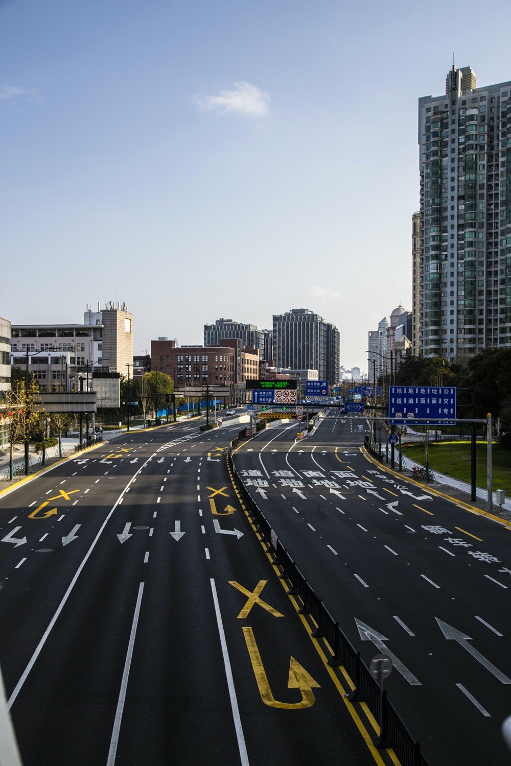
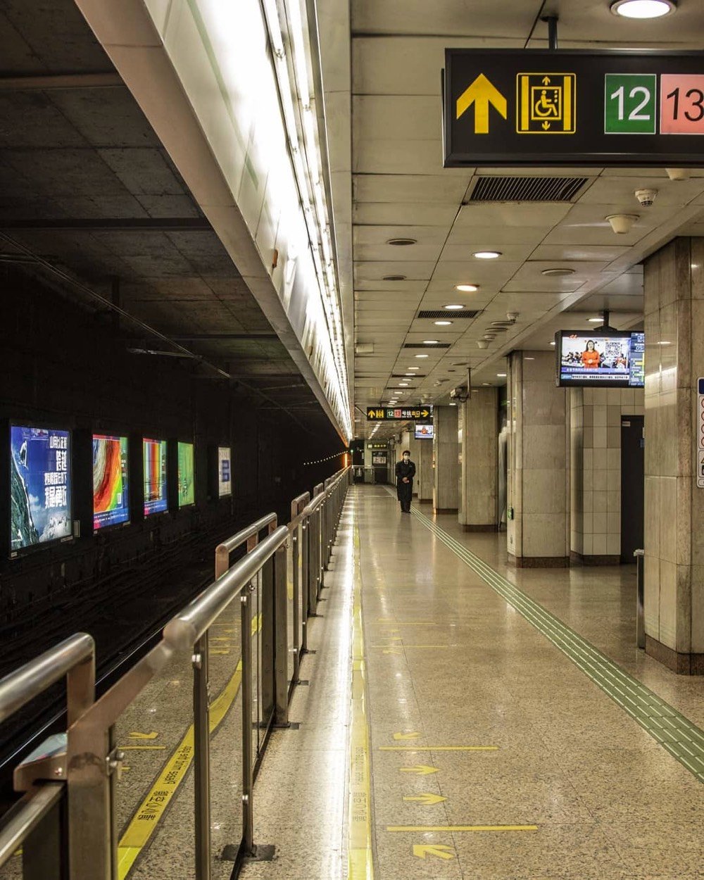
For her series One Person City, photographer nicoco has been taking photos of Shanghai that emphasize how deserted the city was due to the COVID-19 outbreak that has killed more than 1000 people in China. In an interview with Hyperallergic, the photographer said:
My objective for this series was to capture the feeling of apocalyptic emptiness. Some of the photos may look as if they were captured at strange early morning hours, but as a collection, it seeks to reinforce there were no people, anywhere.
These are Shanghai’s busiest locations that can compare to Times Square in New York City, Big Ben in London, the Bean in Chicago, or the Washington Monument in DC. They are very popular on an average day, and very, very popular during holidays as domestic tourists and residents spend time with their families and check out festive displays, shop, or just meander around.
The masterplan of the city includes the designations for street usage into three types: for faster vehicles only, for a mix of lower speed, personal mobility and pedestrians, and for a park-like promenade for pedestrians only. These three street types weave together to form an organic grid pattern to help accelerate the testing of autonomy.
The city is planned to be fully sustainable, with buildings made mostly of wood to minimize the carbon footprint, using traditional Japanese wood joinery, combined with robotic production methods. The rooftops will be covered in photo-voltaic panels to generate solar power in addition to power generated by hydrogen fuel cells. Toyota plans to weave in the outdoors throughout the city, with native vegetation and hydroponics.
Residences will be equipped with the latest in human support technologies, such as in-home robotics to assist with daily living. The homes will use sensor-based AI to check occupants’ health, take care of basic needs and enhance daily life, creating an opportunity to deploy connected technology with integrity and trust, securely and positively.
The press release and video above are the best sources of info about the city, but there’s also a website with not a lot of info and some weirdly fuzzy low-res icons that I hope are not indicative of the level of effort and polish being put into this effort. Those icons definitely didn’t go through the Toyota Production System.
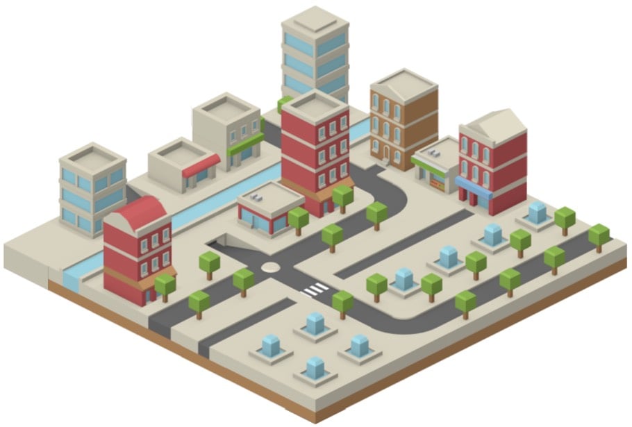
If you are looking for some distraction today (and who would blame you really), check out Victor Ribeiro’s simple little isometric city builder. You just click on a building or snippet of road in the palette and place it on the grid. It took me just a couple minutes to whip this up:
I wish it had more green space options, some wider pedestrian paths, and maybe some bridges. But still fun! (via clive thompson)
Kurzgesagt has partnered with the Red Cross and their “no to nukes” initiative to depict what it would be like if a nuclear weapon detonated in a major city. I’m not going to lie to you here, this is a difficult video to watch. Super bleak. There is no bright side to nuclear weapons.
The reason no government wants you to think about all this is because there is no serious humanitarian response possible to a nuclear explosion. There’s no way to really help the immediate victims of a nuclear attack. This is not a hurricane, wildfire, earthquake, or nuclear accident — it is all of these things at once, but worse. No nation on earth is prepared to deal with it.
Between the climate crisis, the rise of authoritarianism around the world, the AI bogeyman, and other things, nuclear weapons have gotten lost in the shuffle recently, but they remain a massive existential threat to society. A small group of people, some careful planning, years of patience, and you could possibly see an event that would make 9/11 look quaint.
I really enjoyed this piece by architect Scott Hines on how he would design the next generation of baseball stadiums. He starts by talking about greater community buy-in:
Fans want to feel that the club has bought into them, and a bolder model of fan engagement could give them a real stake in the club’s success. One of the most promising recent trends in North American sports is the way soccer clubs are emulating their European counterparts by developing dedicated supporters’ groups. These independent organizations drive enthusiasm and energy in the ballpark, and make sure seats stay filled.
Instead of just acknowledging and tolerating the supporter group model, we’re going to encourage and codify it in the park’s architecture by giving over control of entire sections of the ballpark to fans. Rather than design the seating sections and concourse as a finished product, we’ll offer it up as a framework for fan-driven organizations to introduce their own visions.
This bit about better integrating stadiums into the fabric of the city particularly caught my eye:
We’re going to take a different approach: we’re throwing open the gates, and offering the stadium up to the street. Instead of simply using design touches to emulate surrounding buildings, we’ll erase the distinction between stadium and surround, and put the backs of those supporters’ sections towards the street. We can’t have cars on a concourse, so a series of pedestrianized streets — like those that have been successfully implemented in urban developments like Las Vegas’s Fremont Street, Kansas City’s Power and Light District, or Louisville’s Fourth Street Live — can place the park smack-dab in the middle of a vibrant, multi-use entertainment district, developed with the same open-handed, community-led process as the park itself.
Will some people be able to catch a glimpse of the game without buying a seat? Sure. The club can make money back by leasing land to the businesses drawn in by that activity. And on slow game days, the district can support the ballpark by bringing in people who might decide to catch a couple innings over a beer after dinner at a nearby restaurant. When the ballpark is bursting at the seams for a playoff game? The crowd can flow through the entire district, expanding the ballpark’s capacity greatly.
If you do a Cmd-F on the piece however, you’ll discover that “parking” or “public transportation” is not mentioned anywhere. If you’re trying to smartly weave a stadium into a city, how people get there is a huge consideration. Massive parking lots and gameday traffic tend to disrupt sleek architectural plans and neighborhoodish feeling while many cities don’t have the public transportation infrastructure to support getting a majority of fans to the game without a car.
Twenty-five years ago, physicist Cesare Marchetti argued that people, on average, tend to keep their commutes to about an hour a day, round-trip. For Citylab, Jonathan English looks at how this inclination has interacted with advances in transportation to affect how cities grow and evolve. For instance, walking and travel by horse kept cities to an effective diameter of a few miles, allowing their density to grow over many centuries.
Sure enough, most cities from the ancients to the Industrial Revolution did not grow much bigger than a two-mile diameter. Their core areas were often even smaller, though some of the poor lived in settlements outside the city gates. Ancient Rome packed as many as a million people into an area a little more than two miles in diameter. Medieval Paris stretched about two miles from the Bastille to the Louvre, Vienna’s Innere Stadt measures only one mile in diameter, and the historic City of London is nicknamed the “Square Mile” for a reason. Beijing’s walls enclosed an inner city about three miles in diameter; into the 20th century, that still made up most of the developed area.
Rail, streetcars, bicycles, subways, and cars followed, each increasing the amount of distance from a city’s center that could be reached within Marchetti’s time limit.
The car on the expressway enabled large numbers of people to travel long distances on a day-to-day basis. Instead of small railroad suburbs, where housing was restricted to a short radius around stations, drivers spread out across suburbs could now commute 20 miles in 30 minutes. If the streetcar city covered 50 square miles, the 40-mile-diameter expressway city could cover over 1,250 square miles.*
Urban Nudges is a site that documents small efforts by cities and the people who live in them to slightly change the behaviors of their inhabitants in some way. A 2008 book by Richard Thaler and Cass Sunstein defines a nudge as “any aspect of the choice architecture that alters people’s behavior in a predictable way without forbidding any options or significantly changing their economic incentives”. That sounds a bit academic but some examples from the site clarify things. For instance, protected bike lanes encourage bike riding:
The study “Lessons from the Green Lanes: Evaluating Protected Bike Lanes in the U.S.” was conducted in eight protected bike lanes in Austin, Chicago, Portland, San Francisco, and Washington, DC and the major findings were that bike lanes induced new bikers, mostly because they feel safer about the experience.
The researchers interviewed 2,283 cyclists using the bike lanes and found out that nearly ten percent of the users would have taken another mode of transportation if the bike lane hadn’t existed and around one percent of the interviewed said they would not have taken the trip at all.
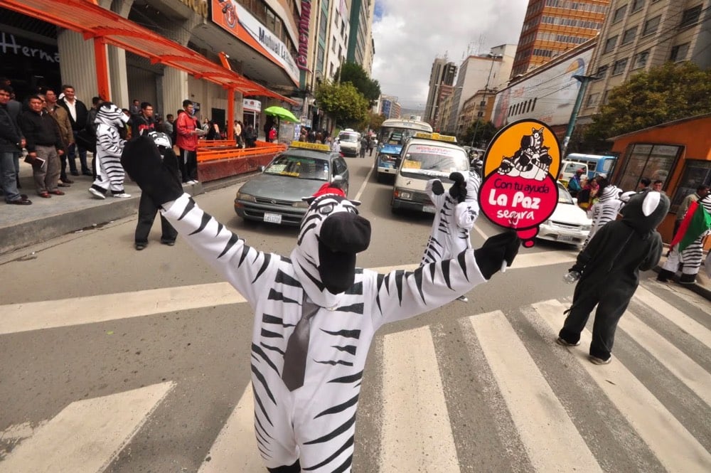
Inspired by the Colombian experience, in Bolivia the Department of transportation developed a program where urban educators get dressed as zebras, teaching children and adults urban values through empathy and comedy. The project’s initial concept was to teach pedestrians and drivers the appropriate use of the pedestrian crossing and reduce congestion: urban zebras rejoice when pedestrians wait for green light and grab their head in agony when pedestrians jaywalk. Empathy, humility and comedy made them popular.
Every driver that passes by the speedometer below the speed limit of 30 km per hour raises EUR0,03 for the neighborhood. “The city’s slogan: Max 30 — Save for the Neighborhood” (Pop Up City). The money raised by this initiative is granted by the city of Amsterdam and is meant to be invested in local community projects.
What kind of nudges could you imagine in your town or city?
For years, I counted this inability to drive as one of many personal failures. More recently, I’ve wondered whether I performed an accidental kindness for the world. I am one of those Darth Vader pedestrians who loudly tailgate couples moving slowly up the sidewalk, and I’m sure that I would be a twit behind the wheel. Perhaps I was protected from a bad move by my own incompetence-one of those mercies which the universe often bestows on the young (who rarely appreciate the gift). In America today, there are more cars than drivers. Yet our investment in these vehicles has yielded dubious returns. Since 1899, more than 3.6 million people have died in traffic accidents in the United States, and more than eighty million have been injured; pedestrian fatalities have risen in the past few years. The road has emerged as the setting for our most violent illustrations of systemic racism, combustion engines have helped create a climate crisis, and the quest for oil has led our soldiers into war.
Every technology has costs, but lately we’ve had reason to question even cars’ putative benefits. Free men and women on the open road have turned out to be such disastrous drivers that carmakers are developing computers to replace them. When the people of the future look back at our century of auto life, will they regard it as a useful stage of forward motion or as a wrong turn? Is it possible that, a hundred years from now, the age of gassing up and driving will be seen as just a cul-de-sac in transportation history, a trip we never should have taken?
City street parking should be considered public space. The current setup is ridiculous: In front of millions of New Yorkers’ apartments, for one example, there are 9-by-18-foot plots of space, available to anyone in the city… if they have a car and want to leave it there. Less than half of the city’s residents own cars, and far fewer can lay claim to any kind of outdoor space. So from Fort Worth to Philadelphia, why not let people use these patches of cement for something they can actually enjoy? Let people set up a table with some food, a little grill, a folding table to sit at and enjoy the sun, and each other. Make space next to the sidewalk. Hatch 10,000 tiny little public spaces in cities that are starved for some life.
A study of seven major U.S. metro areas from UC Davis showed that 91 percent of ride-hailing users didn’t make any changes to their car ownership status, and those that did made up for the reduced miles driven by taking more ride-hail trips. The researchers also found that 49 to 61 percent of all ride-hailing trips wouldn’t have been taken or would have used transit, cycling, or walking had ride-hailing not been an option. Another study by the Metropolitan Area Planning Council put that number at 59 percent in Boston.
Those are key figures because they show that Uber, Lyft, and their competitors not only add car trips in urban centers, they also make existing trips less efficient by shifting them from transit or cycling into a car. This process makes traffic congestion worse because it places more vehicles on the road.
This is a fascinating & provocative article from law professor Gregory Shill: Americans Shouldn’t Have to Drive, but the Law Insists on It. The first line of the piece sets the stage: “In a country where the laws compel the use of cars, Americans are condemned to lose friends and relatives to traffic violence.”
Let’s begin at the state and local level. A key player in the story of automobile supremacy is single-family-only zoning, a shadow segregation regime that is now justifiably on the defensive for outlawing duplexes and apartments in huge swaths of the country. Through these and other land-use restrictions-laws that separate residential and commercial areas or require needlessly large yards-zoning rules scatter Americans across distances and highway-like roads that are impractical or dangerous to traverse on foot. The resulting densities are also too low to sustain high-frequency public transit.
Further entrenching automobile supremacy are laws that require landowners who build housing and office space to build housing for cars as well. In large part because of parking quotas, parking lots now cover more than a third of the land area of some U.S. cities; Houston is estimated to have 30 parking spaces for every resident. As UCLA urban planning professor Donald Shoup has written, this mismatch flows from legal mandates rather than market demand. Every employee who brings a car to the office essentially doubles the amount of space he takes up at work, and in urban areas his employer may be required by law to build him a $50,000 garage parking space.
Cars and car ownership are massively subsidized on a state, local, and federal level and our laws and regulations have built a nation where cars are mandatory and “driving is the price of first-class citizenship”.
Why are we taxing bus riders to pay rich people to buy McMansions and luxury electric SUVs?
And this speed limit thing is just eye-poppingly fucked up:
The National Transportation Safety Board has determined that speed is a top risk factor in motor vehicle crashes. Yet the most prominent way of setting and adjusting speed limits, known as the operating speed method, actually incentivizes faster driving. It calls for setting speed limits that 85 percent of drivers will obey. This method makes little provision for whether there’s a park or senior center on a street, or for people walking or biking.
As a matter of law, the operating speed method is exceptional. It enables those who violate the law-speeding motorists-to rewrite it: speed limits ratchet higher until no more than 15 percent of motorists violate them. The perverse incentives are obvious. Imagine a rule saying that, once 15 percent of Americans acquired an illegal type of machine gun, that weapon would automatically become legal.
Until the 1910s, “street parking was broadly outlawed: if you owned a car in a city, you were responsible for storing it, just as you would be any other piece of movable property.”
“Tax subsidies for commuting prioritize driving. Those who walk, bike, or carpool to work, and in some cases those who take transit, pay other people to drive to work.”
Never realized (or forgot) that CAFE fuel economy rules — generally a good thing — have a loophole that “light trucks” don’t need to be as fuel efficient as cars. “Light trucks” have come to mean SUVs, which means SUVs are easier to produce. No coincidence that the share of “light trucks” has soared from 20% in 1976 to 69% of market today. The upshot, of course, is that SUVs are much worse for pedestrian safety: you’re 3.4x more likely to be killed if hit by an SUV vs. a car.
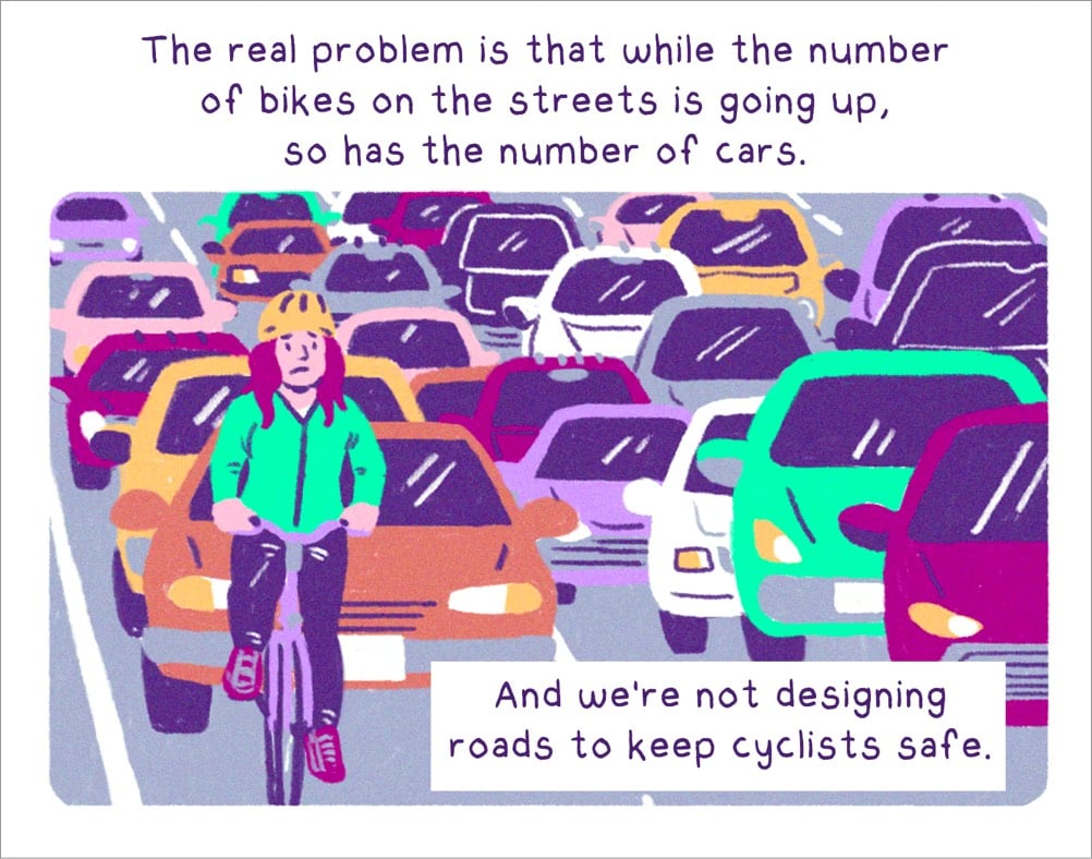
Micromobility, a term coined by Apple analyst and electric transportation enthusiast Horace Dediu, is in the midst of transforming cities. What started with docked bike share, has now moved to dockless electric scooters and e-bikes. And while much of the talk is about how they’re crowding sidewalks or being vandalized, the reality is that they have the ability to fundamentally reshape the geography of cities. When a 25 minute walk or a ten minute Uber ride (with waiting) turns into a 97 cent e-bike ride, the meaning of proximity starts to transform.
When you look at the average distance of trips across different modes of transport it’s clear where the gap is: trips that are long enough to be an annoying walk and short enough to feel like a waste of a car ride. That distance is doable with a regular bike, but if there’s a hill you may be huffing and sweating by the end. The e-bike takes all that away, giving you just enough power to make an otherwise intimidating climb into, at worst, a few aggressive pedals.
Having used dockless e-bikes and scooters over the past few months in various cities, I wholeheartedly agree with Brier here. (And not forgetting that regular old bicycles will also be an integral part of the future of transportation in cities.) This transformation is one that Dean Kamen trumpeted when introducing the Segway in 2001 — the Segway will “sweep over the world and change lives, cities, and ways of thinking” — but the Segway was too early & expensive and now e-scooters and e-bikes are actually set to deliver on that promise.1 The challenge is a political one: how can cities make sure their inhabitants have cheap and easy access to various modes of transportation without sacrificing public safety or having these massive companies like Lyft and Uber come in and gut existing transportation options by selling their services at a VC-funded loss for years?
The Segway was the Apple Newton to the e-scooter’s iPhone…too soon and clunky and expensive for what it did.↩
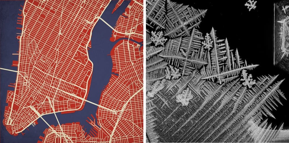
Crystal, towns, and rivers all act according to similar principles governing the formation of things from points and edges. What a world. (via colossal)
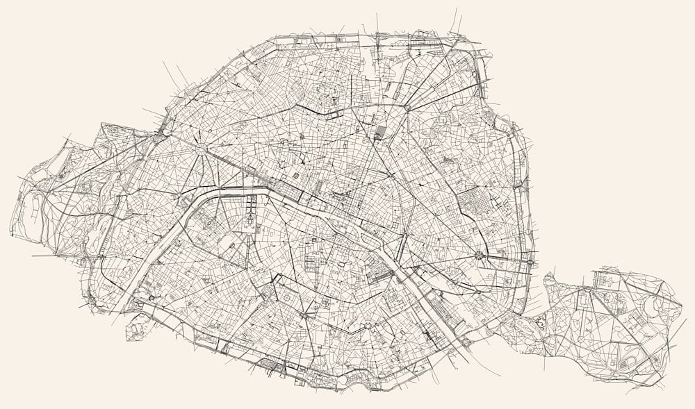
Using geological surveys, geo-referenced road network data, and historic maps drawn the from the collections of the Library of Congress and New York Public Library, Miles Zhang made this time lapse video of the development of the street grid of NYC from 1609 (when Henry Hudson first explored the area for the Dutch) to the present day.
The resulting short film presents a series of “cartographic snapshots” of the built-up area at intervals of every 20-30 years in the city’s history. This process highlights the organic spurts of growth and movement that typify New York’s and most cities’ development through time. The result is an abstract representation of urbanism.
For almost the first half of Manhattan’s history, walking was the primary means of transport. This preference was manifested in the shorter distances between residential, industrial, shipping, and commercial areas — and more frequently their overlap. With street systems, the reliance on the foot is manifested in narrower streets widths not designed to accommodate greater width from carriages, trolleys, and later cars. In fact, the average width of secondary arterial streets increased from 30 feet for streets opened between 1624-1664, to 45 feet for streets opened 1664-1811, and then a uniform width of 60 feet for any cross street opened after 1811. Later widenings increased many of these smaller and pre-1811 streets to width between 100 and 130 feet. In other words, moving from the older networks in the south to newer networks in the north, the width of streets and size of blocks generally increases. These new widths might be influenced by growing population size from only 25,000 in the 1770s, to 64,000 by 1811, and 247,000 by 1834, thereby requiring wider streets for expanding population and higher buildings.
These gradual changes in planning reflected increasing reliance on carriages and horse-drawn trolleys instead of walking. Each mode of transport required a different minimum street width and was associated with different speeds.
The canals, the sewers, the buildings, the bridges and the rest of the Venice’s infrastructure has all been engineered to deal with a particularly challenging environment: not-particularly-solid ground constantly battered by salt water. In this short film, we learn how the city works and what steps have been taken over the centuries to ensure the smooth function of the city.
Whether Venice can survive the severe sea level rise coming in the next few decades is still an open question. (thx, david)
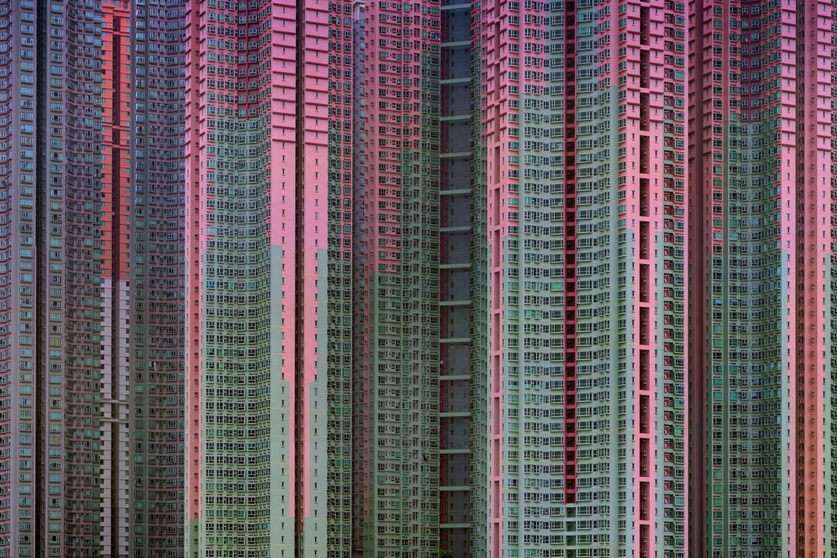
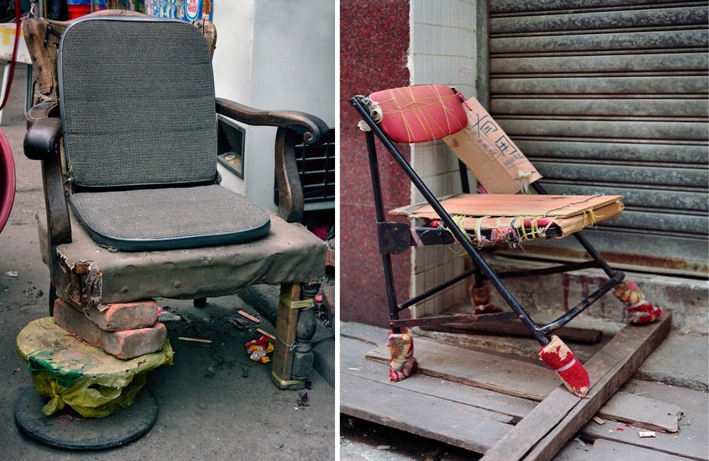
Though seldom commented on by art critics, there was a political undertone to Wolf’s work. In several of his best-known series, even the ones where people were an invisible presence, his striking images point to the human cost and extraordinary resilience of contemporary city dwellers caught up in the Darwinian thrust of global capitalism. For every epic project like Architecture of Density, there were intimately observed series’ created during his various trawls through Hong Kong’s back alleys. There, he caught telling glimpses of the city’s makeshift character: customised chairs, surreal arrangements of kitchen mops and wire coat hangers, twisting gas and water pipes, all the mundane everyday objects that speak of the relentless resourcefulness of its residents, and of Wolf’s eye for accidental sculptural beauty amid the seemingly mundane. A detached gaze, yes, but an expressively tender one all the same. It will be missed.
Wolf’s most well-known project was Architecture of Density, a series of photos taken of the buildings of Hong Kong.
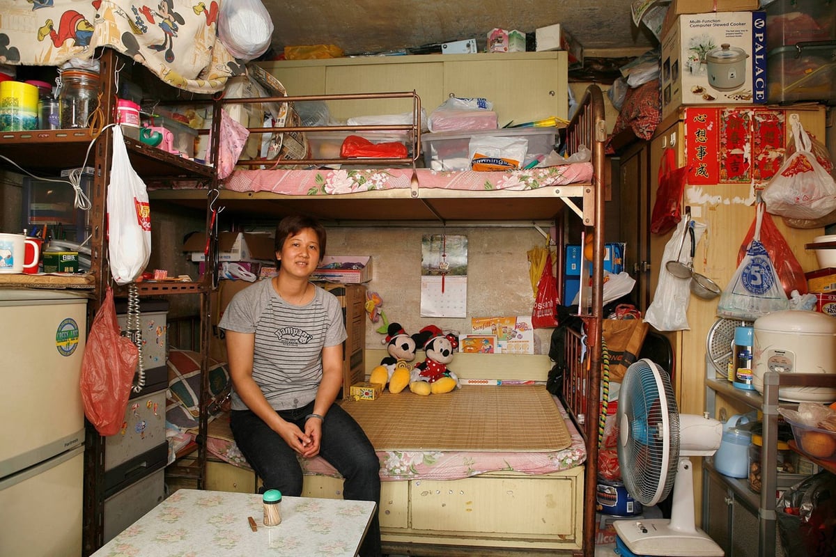
Another Hong Kong project was 100x100, in which he documented 100 apartments of the now-demolished Shek Kip Mei Estate that were each about 100 square feet in size.
Tokyo Compression catches Japanese commuters pressed up against the windows of their train cars.
Bastard Chairs catalogues dozens of improvised devices for seating.
Wolf talked about his work in this short video profile:
You can view Wolf’s complete catalog of work on his website.
At Streetsblog, Angie Schmitt has compiled a handy list of all the ways in which ride sharing services like Uber and Lyft are having significant negative effects on our cities, the environment, and our health.
Uber and Lyft are just crushing transit service in the U.S. A recent study estimated, for example, they had reduced bus ridership in San Francisco, for example, 12 percent since 2010 — or about 1.7 percent annually. And each year the services are offered, the effect grows, researcher Gregory Erhardt found.
Every person lured from a bus or a train into a Lyft or Uber adds congestion to the streets and emissions to the air. Even in cities that have made tremendous investments in transit — like Seattle which is investing another $50 billion in light rail — Uber and Lyft ridership recently surpassed light rail ridership.
Transit agencies simply cannot complete with private chauffeur service which is subsidized at below real costs by venture capitalists.
Uber and Lyft (and their investors) clearly aren’t going to stop…it’s up to cities and communities to take action. They can’t just let these companies ruin their transit until ride sharing is the only thing left.
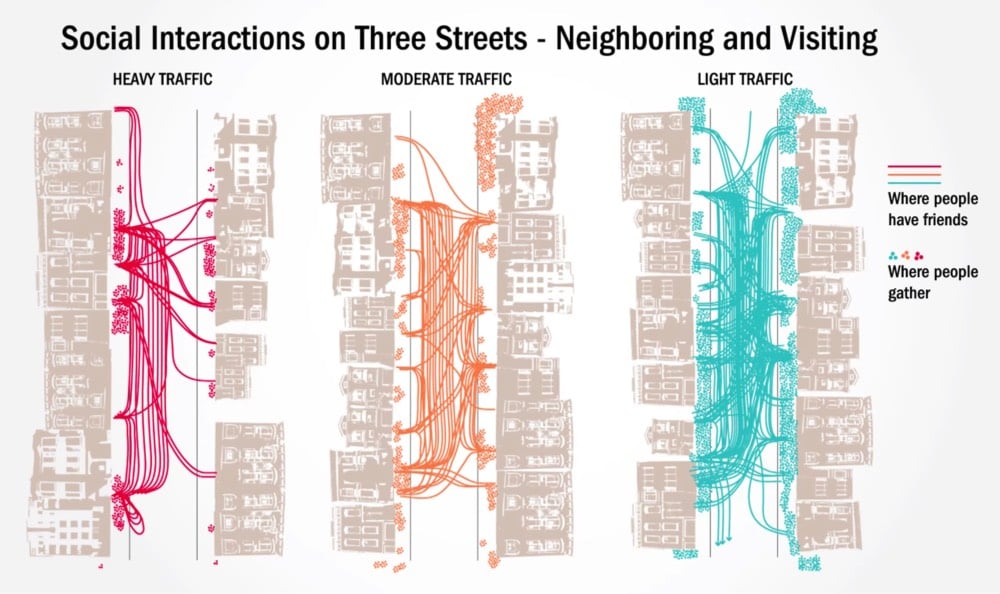
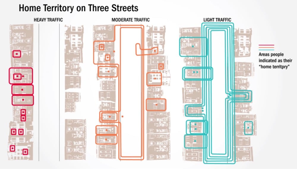
In 1981, a Berkeley urban design professor named Donald Appleyard published a book called Livable Streets (now out of print). In it, he described the results of research he’d done in the late 1960s about the effects of car traffic on the people who live in cities. For the study, he selected three similar residential streets in San Francisco that only differed in the amount of street traffic and then measured how the residents used their streets.
To illustrate his findings, Appleyard used these simple and revealing maps of the data he collected. The first map shows gathering spots on the streets and the friendships made amongst neighbors:
The second map shows what residents considered their “home territory” on their street:
What Appleyard found was that the amount of car traffic on the street dictated how friendly neighbors were with each other, how “at home” people felt in their neighborhood, and how familiar they were with their surroundings.
In the late 1960s Appleyard conducted a renowned study on livable streets, comparing three residential streets in San Francisco which on the surface did not differ on much else but their levels of traffic. The 2,000 vehicles per day street was considered Light Street, 8,000 traveled on Medium Street and 16,000 vehicles passing down Heavy Street. His research showed that residents of Light Street had three more friends and twice as many acquaintances as the people on Heavy Street.
Further, as traffic volume increases, the space people considered to be their territory shrank. Appleyard suggested that these results were related, indicating that residents on Heavy Street had less friends and acquaintances precisely because there was less home territory (exchange space) in which to interact socially.
Light Street was a closely knit community. Front steps were used for sitting and chatting, sidewalks for children to play and for adults to stand and pass the time of day, especially around the corner store, and the roadway for children and teenagers to play more active games like football. Moreover, the street was seen as a whole and no part was out of bounds.
Heavy Street, on the other hand, had little or no sidewalk activity and was used solely as a corridor between the sanctuary of individual homes and the outside world. Residents kept very much to themselves, and there was virtually no feeling of community. The difference in the perceptions and experience of children and the elderly across the two streets was especially striking.
Cars separate people from each other and so does traffic. As @wrathofgnon put it:
This was in 1969, and here we are today in 2018 still building these terrible anti-human suburbs and cities. There is no progress, and there certainly is no science, when we ignore basic common sense and even the studies that prove it.
In 1973, just a few years after Appleyard conducted his research, George Lucas’s ode to American car culture, American Graffiti, came out. Even with the gas and oil shortages in the 1970s, the sense of freedom, rebellion, and individualism depicted in American Graffiti and similar films like The French Connection, Bullitt, Smokey and the Bandit, and Cannonball Run won out over Appleyard’s attempts to show how cars wrecked the social fabric of cities. It was no contest…Americans love cars.
In a sad twist of fate, Appleyard died relatively young at 54 — he was struck and killed by a speeding car in Athens, Greece in 1982.
At the end of October, I spent barely 48 hours in Istanbul — too quick, but I saw a lot of stuff in a short time. When planning this trip, I had a lot of different thoughts about places I could go — the American Southwest, Barcelona, London, Edinburgh, Seattle/Portland, Miami — but the thing that really sold me was a relatively cheap plane ticket that would take me to both Berlinand Istanbul. A two-fer? Sign me up. I’d been to Berlin before, but I was a bit nervous about Istanbul because it seemed so culturally different than other places I’d been. I needn’t have worried.
Just after I had checked into my hotel room, I heard a chanting voice over a loudspeaker coming from outside. I opened my window for a better listen — it was the adhan (the Muslim call to prayer) for the sunset prayer (probably from the Hagia Sophia, which was quite close). As I walked around the city for the next day and a half, I heard the adhan several more times. Watching the sunset in Kadikoy, you could hear the call ringing out from several mosques across the city, nearly in unison. I’m not Muslim or even remotely religious, so I was surprised at how much I liked hearing it. As with tolling European church bells, the calls to prayer knits cities together in an auditory way that secularism has yet to manage.
The nightstand in my hotel room had a sticker on it pointing the direction to Mecca. (There are apps to help with this as well.)
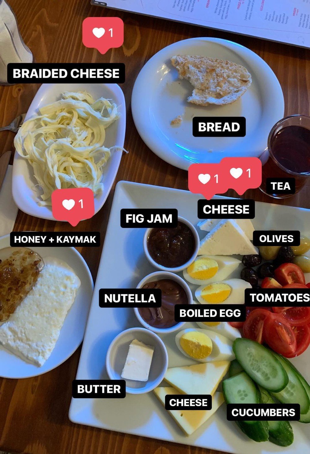
My first morning in Istanbul, I headed to Van Kahvalti Evi for breakfast on the strong recommendation of a reader. What greeted me was an amazing breakfast, the best I have had in quite some time (annotated above). As I was dining solo, I wasn’t able to get full breakfast (it was for 2+ people only), but I did pretty well. My favorites were the braided cheese, kaymak & honey, and the saltiest fresh cheese. The couple sitting next to me ordered the full breakfast and the waiter’s tray was like a magical clown car…he just kept putting little plates of delicious cheeses and pastes and fruits onto the table until it was completely covered. The freshness of everything was underscored by that morning’s food delivery coming in through the front door and streaming past me, a seemingly endless procession of fresh fruit, vegetables, and such. Highly recommended.
Everything I read about Istanbul taxis basically said to avoid them at all costs because they try to rip you off (and I’m not a huge fan of taxis on a good day), so that’s what I did. Upon landing, I bought an Istanbulkart to use the metro & ferries the whole time I was there. Getting from the airport to my hotel was pretty easy on the metro (thanks Citymapper), didn’t take too much longer than a taxi would have, and cost a lot less. Tip: machines are cash only, so you’d better have some Turkish lira on hand before exiting the airport.
Istanbul is not a bicycle city, at least not in the areas I visited. I saw maybe three people on bikes the entire time I was there? For starters, the city streets in the oldest parts of town are so small there’s nowhere to even put bike lanes. And then there are the hills, which made walking challenging at times, never mind biking. Even where there are dedicated lanes, they can be overwhelmed by pedestrians. In a park in Kadikoy, the balık ekmek (fish sandwich) vendors set up their carts right in the bike lane.
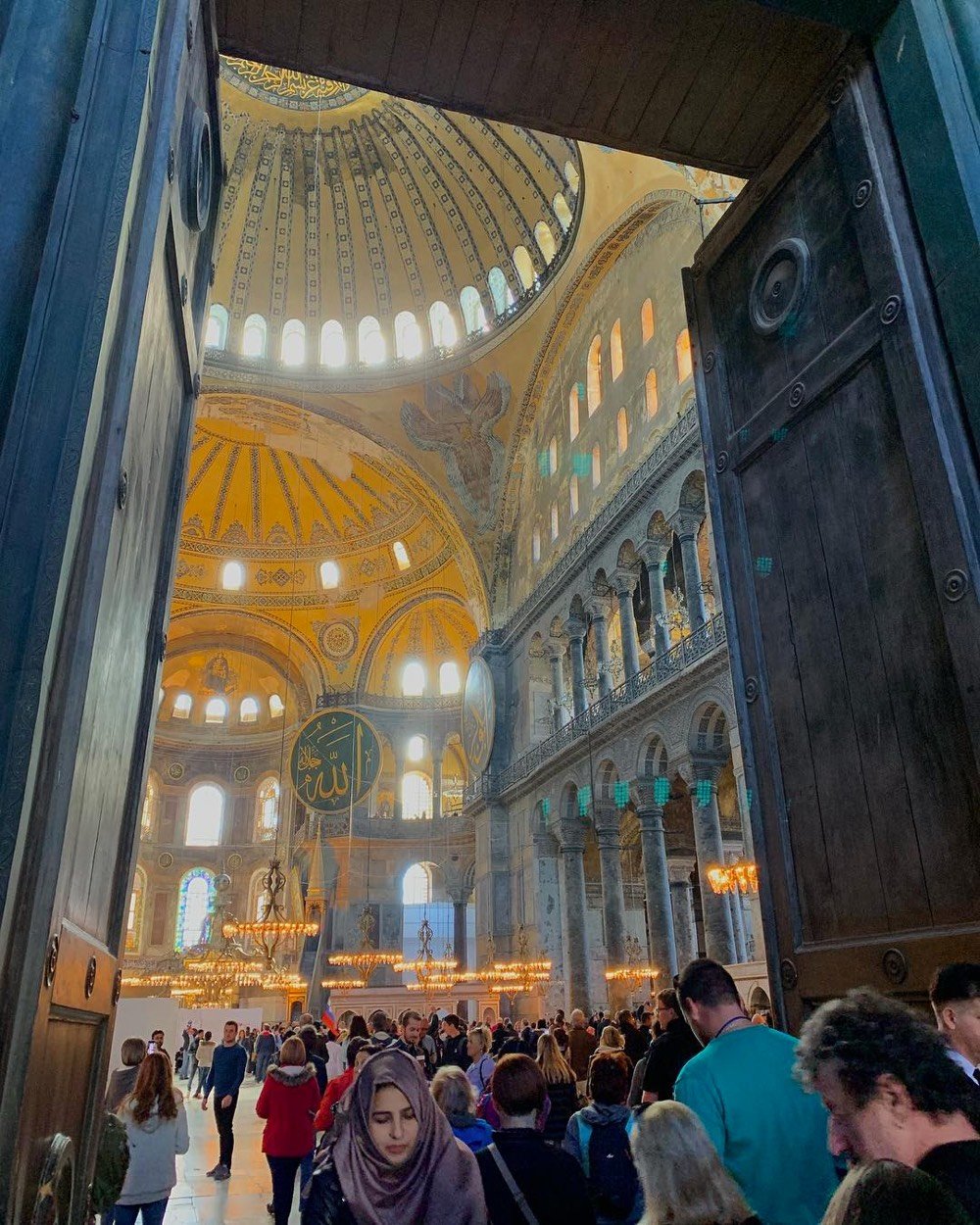
Although the interior was being renovated when I visited, Hagia Sophia was staggeringly impressive. Originally built in just under six years by Emperor Justinian, ruler of the Byzantine Empire (aka what was left of the Holy Roman Empire after the fall of Rome in the 5th century), it was completed in 537 as the world’s largest building and largest cathedral, retaining the latter title for almost 1000 years. Justinian wanted Hagia Sophia to be the biggest church in the world, partially for the glory of God and partially to best his peers. At the building’s dedication, he was recorded as saying, “My Lord, thank you for giving me chance to create such a worshipping place” followed by “Solomon, I have outdone you.” in reference to Solomon’s temple in Jerusalem. IN YOUR FACE SOLOMON!
Hagia Sophia was Byzantine until 1204, Roman Catholic for more than 50 years, and Greek Orthodox for about 200 years after that. In 1453, Mehmed the Conqueror of the Ottoman Empire — wait for it… — conquered Constantinople and turned Hagia Sophia into a mosque. It became a museum in 1935. Walking around inside it, you can see and feel all of this history, layered all around you. The marble floors are worn down from centuries of devoted foot traffic. The wear pattern is uneven due to differing hardnesses of the rocks in the marble, giving the floor a marvelous wavy quality. The Christian aspects of the church were covered or destroyed when the church was converted to a mosque, but now they peek through here and there again. A remarkable experience of time travel through cultures, mirroring Istanbul’s own long and varied history as a crossroads between East and West.
Along with many of its tourists, the overwhelming majority of Turkey’s population is Muslim, so it wasn’t surprising to see women with headwear like hijabs and niqabs all over in Istanbul. I have lots of thoughts about this religious and cultural practice, but mostly it made me think about how the dress of women in the US and other western countries is also restricted by our culture in many ways.
As I had less than 48 hours to spend in Istanbul, I mainly stayed in the central part of the city where most of the tourists were. Walking around was unpleasant at times because it seems like almost everyone is trying to sell you something. In the busiest areas near the top attractions and restaurants, someone tried to sell me a tour, a rug, a meal, or some sweets about every 30 seconds. It was oppressive. I mentioned this to a friend of mine and she said, “Now you know how women feel all the time walking around pretty much everywhere.”
The constant selling also put my guard up far more than it normally is (which is admittedly pretty high). In Taksim Square, a guy asked me for a light and we struck up a conversation. Super friendly guy, said his name was Ahmed, hailed from Qatar, in town for the day on his way to London, was a computer programmer, wasn’t particularly religious, liked travlling alone because his girlfriend (a lawyer) worked and talked too much. He was pleased to find me because this meant us two solo travellers could hang out for the evening. He’d asked at his hotel where to go and was heading towards this place with whiskey and belly dancing. Now, this is the point in the story where I’m supposed to head off into the evening with Ahmed and have an adventure. But because of the constant barrage of selling (plus I was sick and tired and wasn’t drinking), I mostly felt like I was being scammed and that “Ahmed” was actually pals with the guy who owned this belly dancing establishment and was tasked with suckering tourists like me into the place to spend money. Was he just a friendly guy or just another salesman? I still don’t really know, but I bid Ahmed a firm goodbye and still have not crossed “see belly dancing in Istanbul with a stranger” off of my bucket list.
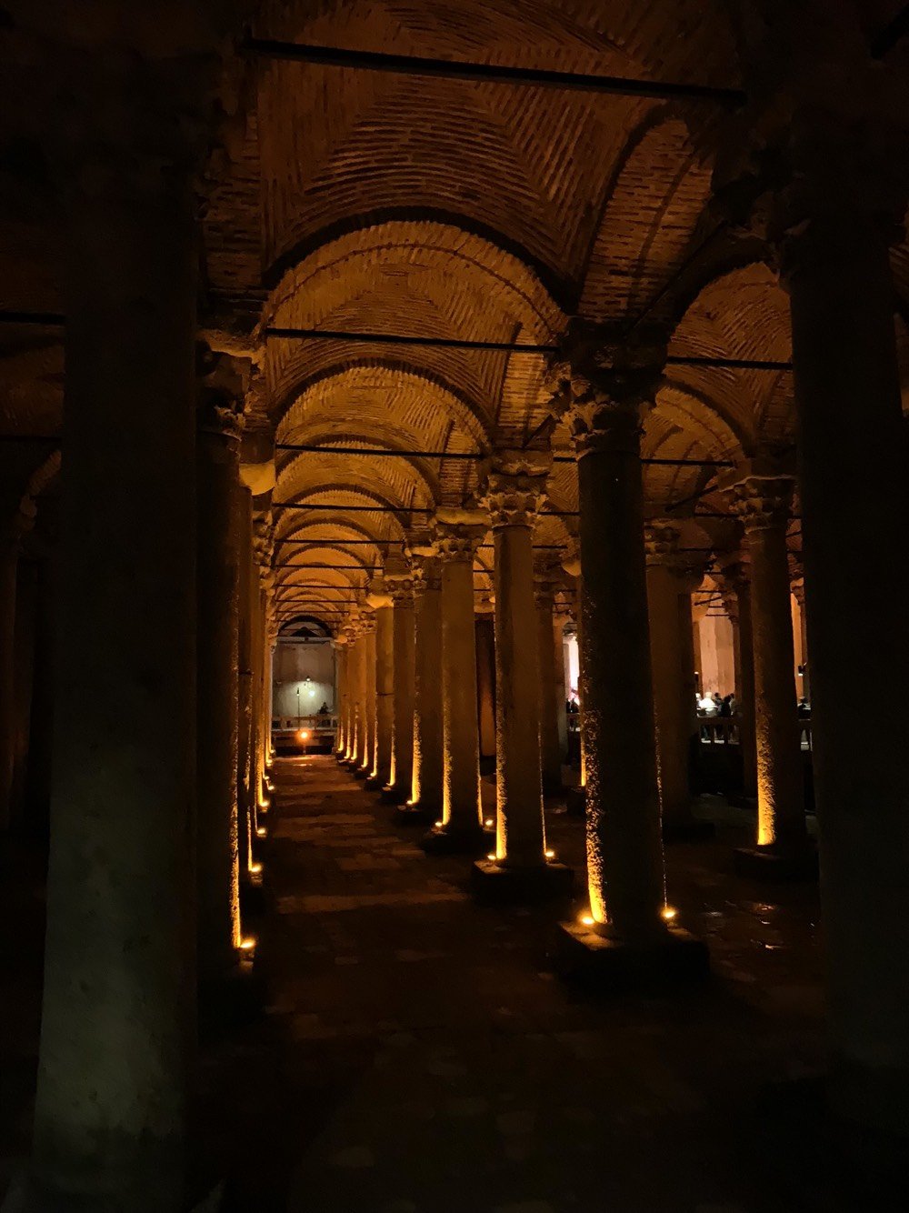
But the next day, I finally succumbed to the relentless pressure. As I was contemplating joining the longish line at the Basilica Cistern, I made the mistake of looking contemplative, as if I were perhaps confused. A man came up to me, asked me if I spoke English, and then said I should come back later when the line is shorter. “Don’t worry,” he said, “I’m not trying to sell you a tour. I’m just on my way back to work from lunch.” Thus disarmed, we started chatting. His name was Musa and he had a business just up the street…perhaps he could give me his card and I could come for a visit tomorrow? Maybe, I said, wanting to be polite. We chatted some more, about other things. I agreed to go with him to get his business card; he still had not mentioned what business he was in…something to do with art, he said.
When we got to his place, it was a rug store. Musa’s friendly onboarding process had worked to get me into the store, penetrating my defenses by using my midwestern politeness against me. We sat down on a nice sofa and Musa served me apple tea; it materialized seemingly out of nowhere, part of a practiced routine. We chatted for about 5 or 10 minutes, sometimes about rugs and sometimes about other things. He told me about watching a TV program that featured this strange street food from NYC: hot dogs. At this point, I was feeling totally suckered, helpless under the thrall of this master salesman. But then I had another thought: this guy is not actually in control of this situation because I’m never in a million years buying a rug from him. Emboldened by my newfound power in our relationship, I thanked Musa politely for the tea, accepted his card, and left to join the line at the cistern.
For dinner on my last night, I sat down at an outdoor table at Meşhur Filibe Köftecisi, figuring that one of the few restaurants where no one was trying to get me to look at a menu was actually a good place to find delicious food. It’s a tiny place on a small street with several other restaurants filled with what looked like locals, another good sign. I asked for a menu but the owner shrugged me off with a friendly gruffness. “We have köfte,” he told me. “Meatballs. Someone like you orders nine. Nine meatballs. Salad to begin. What’s not to like?” I gave him a thumbs up and he yelled something to the chef, an older man who I never saw without a cigarette and had probably made about 10 million köfte over the course of his life.
While I waited for my food, I noticed an order of köfte going out of the kitchen…to a diner at the restaurant across the street. When he was finished, the staff at that place bussed the dishes back across the way. Meanwhile, my meal arrived and the köfte were flavorful and tender and juicy, exactly what I wanted…no wonder the place across the street had outsourced their meatballs to this place. I’d noticed the owner, the waiter, and the cook drinking tea, so after I finished, I asked if I could get a tea. The owner nodded and started yelling to a guy at the tea place two doors down. A few minutes later, a man bearing a tray with four glasses of tea arrived, dropping one at my table and the other three for the staff. Just then, a server from the place across the street came over to break a 100 lira bill. Me being a big nerd, this all reminds me of Unix and the internet, all of these small pieces loosely joined together to create a well-functioning and joyous experience. There’s only one thing on the menu at Meşhur Filibe Köftecisi, but you can get anything else within yelling distance. I declined dessert…who knows where that would have come from.
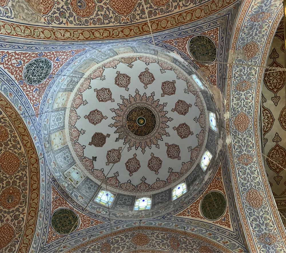
I also visited the Basilica Cistern (impressive ancient infrastructure), The Blue Mosque (under construction and so underwhelming), Topkapi Palace (underwhelming, but I was pretty museumed out by this point so perhaps an unfair assessment), Taksim Square (very crowded on a Friday night), and walked the length of Istiklal Avenue (very commercial in a Western sort of way).
Getting to my departure flight from Ataturk Airport was the tightest security I have ever gone through. To even enter the airport, you go through a metal detector. Then in the line to check into the flight, my passport was checked by three different people before my boarding pass was issued. Passport & boarding pass were checked again to get into the security line and then went through security, where most people’s bags got searched (but not mine). At the gate, my boarding pass was checked by at least six different people, who each put a different mark or stamp or signature on it, and then my carry-on luggage was searched (mandatory search…everyone got this treatment). Only then were we allowed on the plane. (Upon arrival in Boston, after waiting in a massive line, the border control officer barely glanced at my passport before waving me through.)
I only posted a couple of Istanbul photos on Instagram but posted a bunch of Instagram Stories (collected here). And big thanks to everyone who offered advice on where to go and what to eat. I really enjoyed Istanbul and hope to make it back someday.
In just a few years, Sevilla, Spain went from almost no bike paths and low ridership to robust network of bike paths and many people using them. To do it, the ruling party used the positive results of a public poll to move quickly, annexing 5000 parking spots and spending a relatively meager €32 million to build 80+ kilometers of bike paths in just 18 months.
The year after the basic network opened, Calvo said, it seemed like every family in the city had suddenly bought one another bicycles for Christmas.
“Everyone was talking about the success of the bike lanes at that point,” he said. “The sports shops, they ran out of bikes. They needed to get bikes from Barcelona, from Madrid, and over from France.”
Once that happened, it became clear that the huge bike network investment had been a fiscal bargain.
“The whole network is €32 million,” he says. That’s how many kilometers of highway - maybe five or six? It’s not expensive infrastructure. … We have a metro line that the cost was €800 million. It serves 44,000 trips every day. With bikes, we’re serving 70,000 trips every day.”
Even for a city almost 800 years old, Berlin has seen more than its fair share of history, especially in the 20th century. Watching the fall of the Berlin Wall on television 29 years ago this month was one of my most memorable experiences as a teen. In 2001, my girlfriend and I visited Berlin, loved it, and wanted to return soon. But you know how that goes sometimes, and I didn’t make it back there for a visit until mid last month, when I spent the better part of a week exploring Germany’s largest city. Here are of my impressions from the trip.
Museum-going is one of my favorite things to do when travelling and Berlin has a bunch of great ones. And they’re not generally these behemoths like the Met or Louvre…they’re reasonably sized places you can knock out in a couple of hours. The recreation of the Ishtar Gate at the Pergamon is one of my favorite things at any museum I’ve been to.
The public transportation in Berlin is great. One ticketing scheme covers buses, trams (in the old East Berlin), surface trains (S-Bahn), and subways (U-Bahn). I bought a weekly pass and used it to travel all over the city. One afternoon with no fixed agenda, I explored by randomly hopping on trams and trains and getting off when things started looking interesting…navigation by an arbitrary stupid goal.
Yes, I had the currywurst. And a kartoffelpuffer (served with a massive dollop of delicious sour cream w/ herbs in it). I preferred the knackwurst I got from Konnopke’s Imbiß and the schnitzel from Scheers, which reminded me a bit of Crif Dogs (but for schnitzel). The guy at Konnopke’s made an “ick” face when I asked for ketchup with my knackwurst instead of mustard. *shrug*
According to Pedometer++, I walked 65 miles over a 7 day period in Berlin.
My favorite thing about public transport in Berlin is that instead of having entry turnstiles and swiping your ticket when you get on the bus, you simply buy a ticket and get it stamped on the platform to validate it. That’s it. With my weekly pass, I had to stamp it once to “activate” it, but after that, I could just get on the tram or subway without worrying about it. I love this system…it eliminates so much infrastructure, makes it easier to use public transport, and doesn’t track you around the system like smartcards do. It also makes it easier to ride for free, although there are teams of ticket inspectors moving throughout the system checking for valid tickets. Fines of €60 on up are assessed & paid on the spot.
A team of three undercover ticket inspectors got onto a tram I was riding…they were young, dressed a bit like hooligans, and looked way more like they were gonna steal wallets than officially check tickets. After nonchalantly boarding, they announced themselves to the passengers, pulled out their badges, and worked very quickly, impatiently looking at tickets before the tram pulled into the next stop and scofflaws could escape.
The Memorial to the Murdered Jews of Europe is an open-air memorial of more than 2700 concrete slabs arranged in a grid pattern. While I was there, I saw it being used as a bench, a picnic area, a playground, a hide-n-go-seek maze, a selfie background, a parkour apparatus, and as the backdrop for Instagram influencers…pretty much everything but thoughtful reflection about the murder of 6 million people. See also Yolocaust.
Everyone kept telling me that the city had changed so much since I’d been there, but one of the only differences I could detect was that in 2001, it was pretty easy to tell which parts of the city had been in East Berlin and which had been in West Berlin, just by looking at the buildings and streets. Now, aside from the presence of random Soviet monuments and the tram in the former East Berlin, I couldn’t really tell. After almost 30 years, Berlin finally seems like a single city again (at least to this outsider).
The Deutsches Technikmuseum (German Museum of Technology) is actually huge and completely amazing, especially the collection of trains and train cars housed in the massive buildings of a former railway company. The smell of grease and oil that hit me walking into the exhibition took me right back to when I was a kid, helping my dad fix cars in the garage. As I mentioned in this post, the exhibition included a freight car that was used for transporting Jews to concentration camps that you could walk inside of “and try to imagine, in some small way, you and your children cheek to jowl with 80 other people, on the way to be murdered”. An intense experience.
The massive seven-story KaDeWe department store has an entire floor dedicated to food (in addition to the eatery on the top floor) and the butcher cases must have featured over 120 different kinds of sausage & wurst…it was unbelievable. I spent more than an hour wandering through and ended up having dinner, some scrambled eggs with a side of potatoes and onions — the menu had a disclaimer on the bottom of each page: “Of course our potatoes and onions are made with bacon!” Duh, this is Germany.
The permanent exhibition at the Topographie Des Terrors is a must-see presentation of how the Nazis persecuted, imprisoned, and murdered millions in the 30s and 40s. While sobering and completely gutting in parts, this was one of my favorite things I did in Berlin.
While not quite public transport, Berlin has a thriving bike share scene. I signed up for Mobike because they seemed to have the most inventory. As a bike-friendly city to begin with, there are lots of places on the streets to park these dockless bikes, although locals have complained about bike littering. This was my first time using a dockless bike, and like with WiFi on a laptop or pairing a Bluetooth speaker, the first time feels a little magical.
My favorite meal was at the restaurant in my hotel. That’s a bit of an odd thing to hear because we’re used to hotel restaurants being kind of a default mediocre. But the food at the Michelberger’s restaurant was delicious, surprising, and inventive. I had the burrata w/ pear & dukkah and the arctic char w/ smoked mashed potatoes & buttermilk. Just thinking about that meal is making me hungry!
Berlin reclaimed Tempelhofer Field as a public park after the Tempelhof airport closed in 2008. I’d never walked on a large runway like that before…they’re huge! I was supposed to meet up with Felipe of Fotostrasse to take a more extensive tour of the area, but it was rainy and I was sick, so I only managed a quick solo visit. Next time!
I only posted a coupleof pics from Berlin on Instagram, but I did post a bunch of Instagram Stories (collected here). And thanks to everyone on Twitter and Instagram who offered suggestions for my trip! I had a great time and I will definitely be back, hopefully before 17 more years have passed.
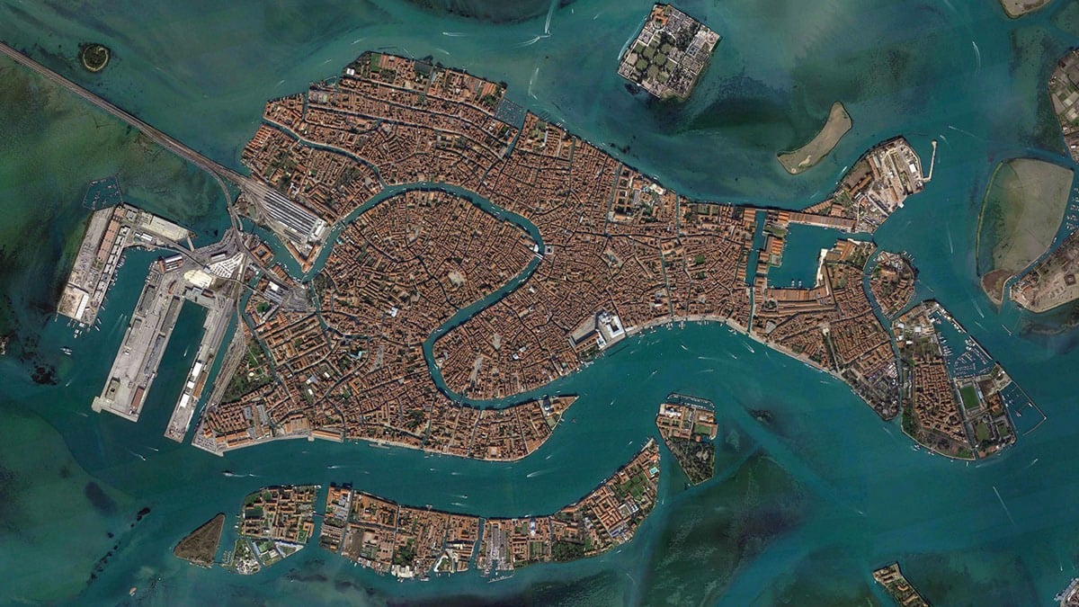
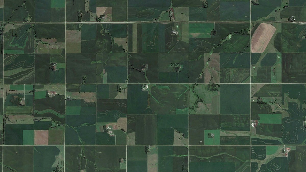
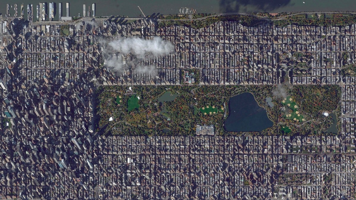
Spending time looking at the varying and beautiful images of our planet from above in Google Earth, zooming in and out at dizzying rates, I thought it would be interesting to compare all of these vistas at a fixed scale-to see what New York City, Venice, or the Grand Canyon would look like from the same virtual height.
Each of the 38 images selected by Taylor shows about seven square miles of the Earth’s surface. The three images I’ve excerpted here are, from top to botton, Venice, Wisconsin farmland, and Manhattan. This planet really is dizzyingly beautiful.
This reminds me of The Jefferson Grid project (showing 1 sq mile satellite photos of the US). There’s another project which I swear I’ve seen recently that shows the grids of streets in cities from around the world and how they vary widely, but I can’t find it. Anyone?
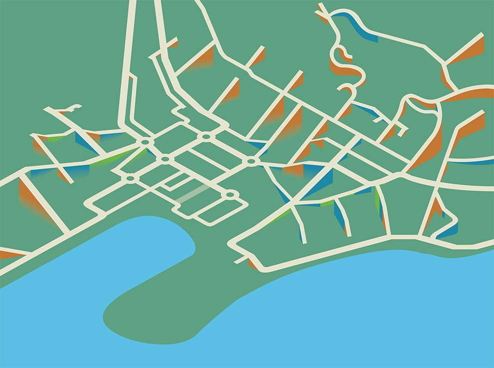
I’ve often said that every two-dimensional map is a lie; a perfect map would be able to show a city in three dimensions. (Or four, to show how they’ve changed over time.)
Height tells you so much; the steepness of streets, where water tends to flood, even often class distinctions, at least traditional ones. Try walking around San Francisco sometime, or Gloucester, Massachusetts, following a map that tells you take a left turn, straight uphill. Better still, try this in a wheelchair.
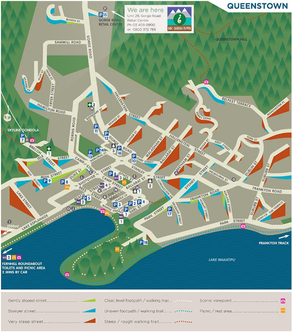
Toby Eglesfield, a graphic designer working in New Zealand, took this challenge seriously. After some aborted attempts with arrows, he settled on a trimetric projection (it’s like isometric, but slightly different), with different colored wedges to indicate the relative steepness of a street. Here’s the basic idea:
And here’s the completed product:
Created for the disAbilities Resource Centre in Queenstown, the map includes marks for accessible toilets, car parks, etc. I’d love to see a version for Manhattan, San Francisco — anywhere, really, but especially older cities with varied topography.
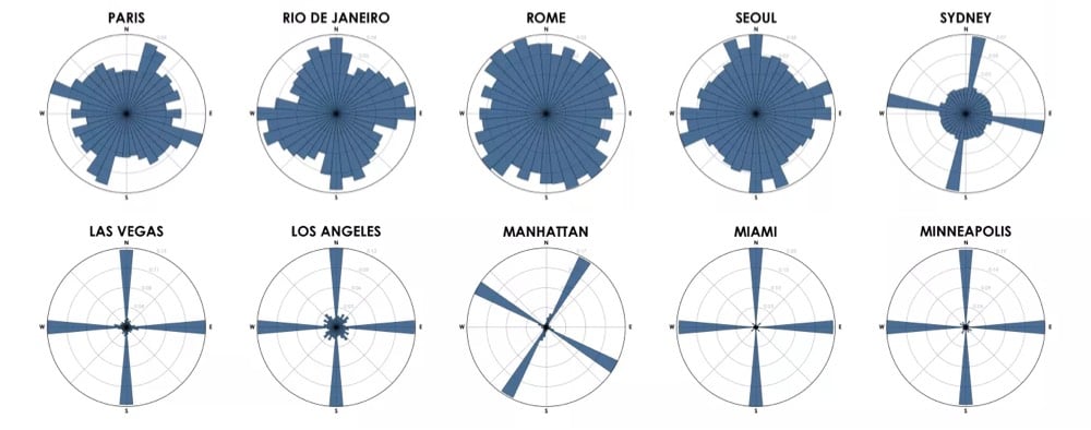
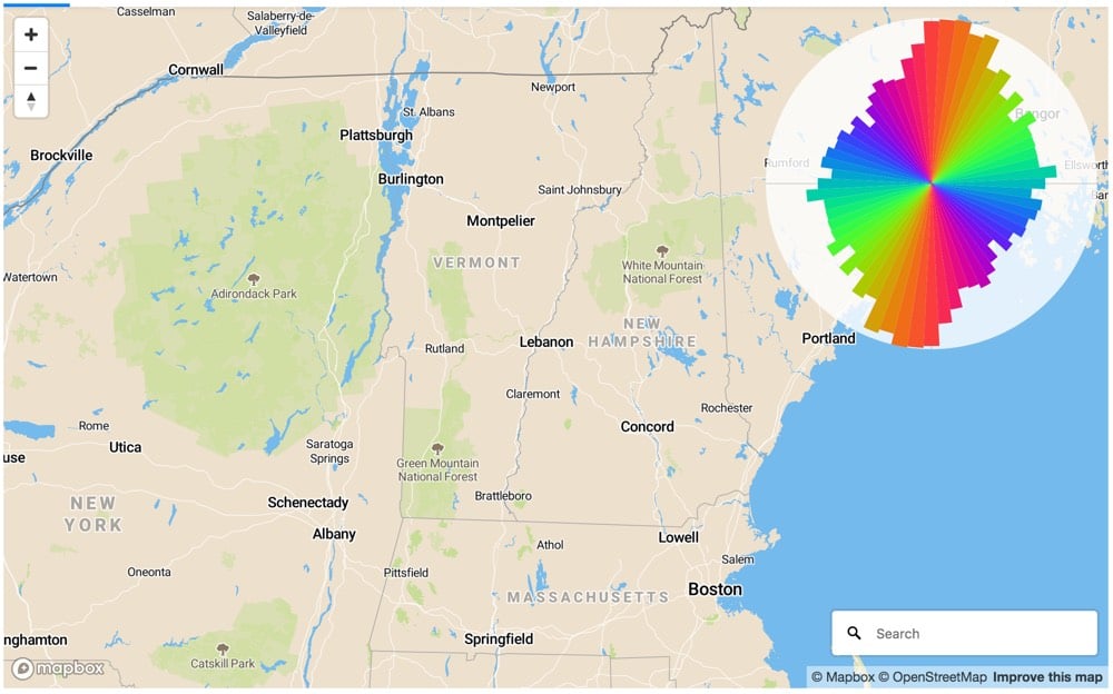
Each of the cities above is represented by a polar histogram (aka rose diagram) depicting how its streets orient. Each bar’s direction represents the compass bearings of the streets (in that histogram bin) and its length represents the relative frequency of streets with those bearings.
Looking at these graphs, you get a real sense of just how planned American cities are compared to much of the rest of the world, where cities grew more organically over longer periods of time. (Although I’m curious to see what the graph for all of NYC would look like…a bit more like Boston perhaps.)
Update: Using Mapbox, you can generate street orientation charts for any map view. I used it to verify that north-south roads outnumber east-west roads in New England, which is why it takes so long to go 30 miles across VT compared to up or down.
Unfortunately, America’s inherited infrastructure is more like the old Embarcadero Highway than the boulevard that replaced it. Urban planners spent the 20th century building cities for cars, not people, and alternatives to driving have been systemically undervalued. This legacy has resulted in substandard health outcomes, missed economic opportunities, and a shortage of affordable housing.
We can’t wait around for another earthquake to reverse generations of bad policy. Luckily, it doesn’t require a natural disaster to begin reshaping our infrastructure. Small changes can have an outsized impact in expanding alternatives for how people move around. Rebuilding our infrastructure to enable walking, cycling, and mass transit would bring health and economic benefits that far outweigh its price tag.
People who live in rural areas more or less need their own cars in order to do anything, but private cars in cities are much less necessary. Cities should optimize for buses, subways, cyclists, and pedestrians — they get people to where they’re going without all the outsized infrastructure, waste, and pollution. *repeatedly sticks pin into voodoo doll of Robert Moses*
Market Street offers a glimpse of how contemporary U.S. cities might be edging towards that shared-street mentality (a proposal to completely ban private cars from the street was ahead of its time). But it also illustrates something else — if you give people ample space to move at a safe speed using the mode of their choice, anyone can use the street.
All over the country, city leaders are spending their summers devoting careful thought to the number of rentable e-bikes that can be deployed on streets at once, where electric scooters might be parked, and how dockless companies should be punished for violating these terms. Just this week, the National Association of City Transportation Officials, which collates best practices from its 62 member cities, released draft guidelines around the regulation of “small vehicles.”
Yet largely absent from these decisions — at least the public-facing ones — are how cities plan to quickly and dramatically reconfigure their streets to allow people to actually use anything but a car.
In The Death of a Once Great City Kevin Baker argues that the current affluence of NYC has made the city “unremarkable” and “boring”.
New York has been my home for more than forty years, from the year after the city’s supposed nadir in 1975, when it nearly went bankrupt. I have seen all the periods of boom and bust since, almost all of them related to the “paper economy” of finance and real estate speculation that took over the city long before it did the rest of the nation. But I have never seen what is going on now: the systematic, wholesale transformation of New York into a reserve of the obscenely wealthy and the barely here — a place increasingly devoid of the idiosyncrasy, the complexity, the opportunity, and the roiling excitement that make a city great.
As New York enters the third decade of the twenty-first century, it is in imminent danger of becoming something it has never been before: unremarkable. It is approaching a state where it is no longer a significant cultural entity but the world’s largest gated community, with a few cupcake shops here and there. For the first time in its history, New York is, well, boring.


Stay Connected